DIGITAL PRODUCT
Scenic spot guide system
The Scenic Area General Navigation and Marking System is a lightweight, self-configurable smart navigation system for scenic areas that is compatible with all terminals and a multi-map ecosystem. It integrates map access, location marking, route planning, intelligent interpretation, user interaction, and multi-business location management. The system focuses on the digital tour operation needs of scenic spots and can be quickly implemented without complex development. It comprehensively covers tourist services and scenic spot back-end operation and maintenance management scenarios and is suitable for various natural scenic spots, cultural scenic spots, cultural and tourism complexes, park attractions and other scenarios.
Scenic Area General Navigation and Marking System Description
The Scenic Area General Navigation and Marking System is a lightweight, self-configurable smart navigation system for scenic areas that is compatible with all terminals and a multi-map ecosystem. It integrates map access, location marking, route planning, intelligent interpretation, user interaction, and multi-business location management. The system focuses on the digital tour operation needs of scenic spots and can be quickly implemented without complex development. It comprehensively covers tourist services and scenic spot back-end operation and maintenance management scenarios and is suitable for various natural scenic spots, cultural scenic spots, cultural and tourism complexes, park attractions and other scenarios.
I. Full-terminal adaptability
The system adopts a cross-terminal adaptation architecture to fully adapt to the browsing and usage habits of different users, achieve data interoperability and function synchronization across multiple terminals, and ensure a comprehensive user experience.
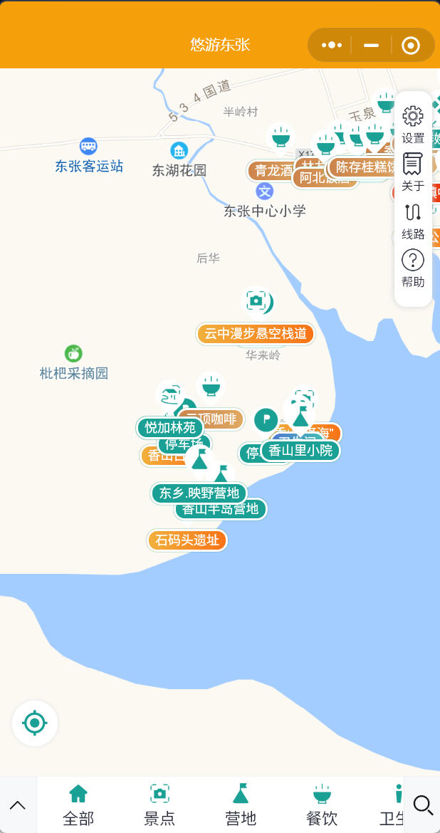
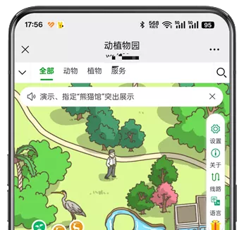
1. WeChat Mini Program: Lightweight to use, no download or installation required. Visitors can quickly enter the system by scanning a QR code, view scenic spot maps, location information, tour routes, and listen to intelligent commentary. It is convenient to operate and has strong reach.
2. PC Management Terminal: For scenic area operation and management personnel, it provides complete backend configuration, annotation editing, content review, data management, and site operation and maintenance functions, supporting refined and batch backend operations and adapting to office operation and maintenance scenarios.
3. WAP mobile web version: Adapts to mobile browsers for adaptive access, is compatible with various mobile devices, has no platform restrictions, and can be accessed directly through links and QR codes, filling the blind spots in mini-program coverage and achieving omnichannel reach.
II. Autonomous access capabilities for multiple types of maps
The system is highly compatible, supporting scenic spots to independently choose to access mainstream map service providers. It can be flexibly switched according to the scenic spot's geographical adaptation, usage needs, and authorization status without changing the system architecture, and the access process is simple and efficient. Map types supported for access includeGaode Maps, Baidu Maps, Tencent Maps, TiandituIt adapts to mainstream map data sources such as map accuracy, layer display, and positioning service needs in different scenarios, while retaining the general functions of map basics such as zooming, panning, ranging, and positioning to ensure a basic navigation experience.
III. Background Visual Autonomous Labeling Management
The system backend is equipped with a visual map marking function, allowing operators to independently complete custom marking, editing, adding, deleting, and modifying the locations and routes of all attractions in the scenic area without professional technical skills, thus achieving independent control and real-time updates of the scenic area's guided tour content.
1. Location Marking: Supports custom marking of various core locations in the scenic area, including attractions, entrances and exits, parking lots, restrooms, shops, service centers, rest areas, etc., which can accurately match latitude and longitude coordinates, and the display style of the locations can be customized.
2. Route markings: The dual-route system is independently configured to fully cover the needs of scenic spot sightseeing and passage. First,Driving routeIt can mark the external passage routes, internal vehicle lanes, parking passage routes, etc. of the scenic area to adapt to the passage guidance for self-driving tourists; SecondTour routeBased on the characteristics of the scenic area, multiple personalized tour routes such as day trips, highlight tours, family tours, and hiking tours can be planned, connecting various attractions and locations to provide tourists with standardized tour references.
IV. Multimedia Information Display and Intelligent Explanation of Scenic Spots
The system breaks through the limitations of traditional text guides, builds a comprehensive multimedia attraction introduction system, and is equipped with positioning-triggered intelligent explanation functions to enhance the immersive tourist experience.
1. Multimedia content display: Each attraction supports rich introductory content, including text introductions, real-life pictures, promotional videos, popular science materials, travel tips, etc., showcasing the cultural background, highlights, and precautions of the attractions from multiple dimensions. The content can be updated and replaced in real time in the background.
2. Automatic latitude and longitude commentary: Based on LBS positioning technology, after tourists arrive at the corresponding latitude and longitude coverage area of the attraction, the system can automatically trigger voice commentary without manual clicking, realizing immersive intelligent guidance "wherever you go, wherever you talk"; It also supports manual clicking of location start and stop commentary, adapting to the usage habits of different tourists.
V. User Content Feedback Interactive Function
The system has established a two-way interactive channel to support visitors in providing feedback on the content of scenic spots and guided tours, helping the scenic spot to continuously optimize its services. Visitors can submit written feedback and photo evidence regarding issues such as incorrect information about attractions, inaccurate route markings, outdated facility information, and missing newly added locations. The backend can receive and review user feedback in real time, create a feedback record ledger, support targeted modification and optimization of guided tour content, and achieve dynamic iterative upgrades of scenic area guided tour services.
VI. Management of Multiple Transit Points in Scenic Areas
The system supports the customization and management of diversified operating locations in scenic areas, adapting to the diversified operational needs of scenic areas. It can independently label and classify and manage various business locations in scenic areas, including cultural and creative shops, catering and snack shops, amusement rides, homestays and hotels, retail stalls, experience venues and other business formats; It supports separate configuration of introductory content, opening hours, pricing standards, contact information, and real-scene materials for each multi-point location, which not only makes it convenient for tourists to quickly check the scenic area's consumption and experience services, but also facilitates the scenic area's unified management of diversified business resources and realizes integrated management of tourism services and operation.
VII. Core System Advantages
1. High versatility: Suitable for all types of scenic spots, with no scenario restrictions, and a standardized architecture supports rapid deployment and implementation;
2. High autonomy: The entire process can be configured independently in the backend, with maps, locations, routes, and content all customizable without the need for technical development;
3. Full terminal coverage: Mini programs, PCs, and WAP are interoperable to meet different usage scenarios for visitors and maintenance personnel;
4. Intelligent Experience: Positioning automatic commentary and multimedia content display upgrade the smart tour experience;
5. Iterative operation: User feedback + dynamic content updates help continuously optimize scenic area guide services.